
High in the rugged Caucasus Mountains lies a monumental archaeological marvel: Dmanisis Gora. Long known to researchers but newly redefined through drone mapping technology, this 3,000-year-old mountainside fortress has revealed itself to be a sprawling, sophisticated settlement far exceeding its previously understood scale. The discovery not only highlights the ingenuity of ancient societies but also reshapes our understanding of Late Bronze and Early Iron Age dynamics in the South Caucasus.
Historical Context of Dmanisis Gora
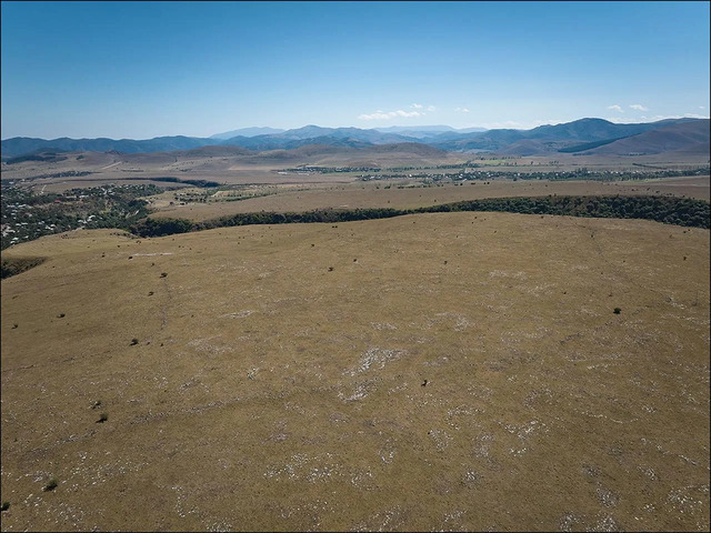
Situated at the crossroads of Europe, the Eurasian Steppe, and the Middle East, Dmanisis Gora reflects a unique cultural mosaic. This region, often a melting pot of civilizations, became a focal point of evolving social and political structures during the Late Bronze and Early Iron Ages. The fortress, with its imposing fortifications, suggests its builders were part of a society marked by increasing complexity and strategic territorial planning.
The South Caucasus has long been a land of cultural exchange, where trade routes and pastoralist migrations converged. In this environment, Dmanisis Gora served as more than just a defensive stronghold—it was a hub of interaction, innovation, and adaptation.
Drone Mapping and Technological Innovations
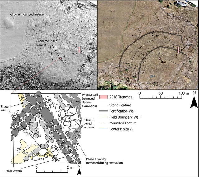
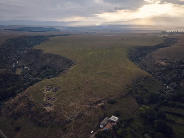
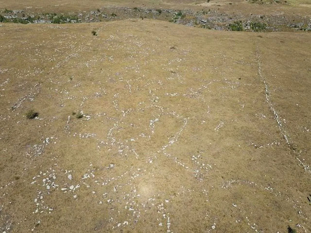
The recent revelations about Dmanisis Gora owe much to advancements in archaeological technology. Initial excavations on a fortified promontory between two deep gorges hinted at the site’s significance, but it wasn’t until the use of drone mapping that the fortress’s true scale came to light.
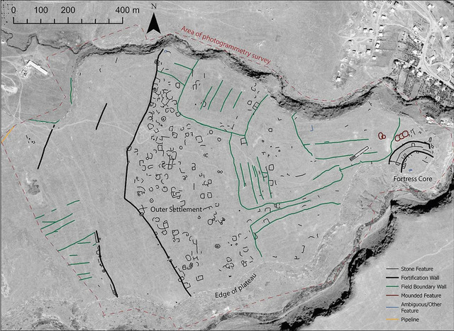
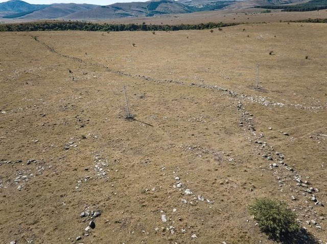
Researchers, led by Dr. Nathaniel Erb-Satullo and Dimitri Jachvliani, deployed drones to capture nearly 11,000 aerial images. These were processed using sophisticated software to generate high-resolution digital elevation models and orthophotos. By combining these images with declassified Cold War–era satellite data, researchers distinguished ancient architectural features from more recent alterations caused by modern farming. The findings revealed that the outer settlement of Dmanisis Gora was protected by a kilometer-long fortification wall, making the site over 40 times larger than initially thought.
Video
Watch as a drone reveals the shockingly huge size of a 3,000-year-old Caucasus settlement – explore this ancient site from a new perspective in the video!
Architectural and Settlement Features
The scale and design of Dmanisis Gora’s fortifications are awe-inspiring. Stretching a kilometer in length, the defensive walls enclosed not just the inner fortress but a vast outer settlement. Within this perimeter, researchers identified remnants of stone buildings, graves, field systems, and other structures. These findings suggest that the fortress was a central point of activity and habitation, strategically positioned to oversee and protect the surrounding region.
The architecture reflects an investment in stone construction, indicating the resources and labor available to its builders. Despite this, evidence suggests the site was only intermittently occupied, possibly during seasonal migrations or periods of heightened conflict.
Social and Economic Dynamics
The settlement dynamics of Dmanisis Gora paint a picture of a society that balanced mobility and stability. Researchers propose that the fortress’s size was influenced not only by the resident population but also by the influx of mobile pastoralists. This transient population likely contributed to the seasonal growth and contraction of the settlement, reinforcing the importance of the site as a hub for trade, security, and cultural exchange.
Artifacts unearthed during ongoing excavations provide further insights into the daily lives of its inhabitants. Pottery shards, animal bones, and other relics reveal a community engaged in livestock management, agriculture, and trade. These findings underscore the fortress’s role as both a defensive structure and a thriving economic center.
Cultural Continuity Amidst Regional Upheaval
The Late Bronze and Early Iron Ages were periods of significant upheaval across the Near East and Eastern Mediterranean, often referred to as the “Bronze Age Collapse.” However, the South Caucasus appears to have been an exception. While other regions experienced widespread disruptions in settlement and material culture, Dmanisis Gora shows remarkable continuity.
The fortress’s architecture and artifacts suggest that its inhabitants maintained stable societal structures even as neighboring regions faltered. This resilience offers a valuable counterpoint to prevailing narratives about the era and highlights the adaptive strategies of communities in the Caucasus.
Implications for Archaeology and Future Research
The discoveries at Dmanisis Gora have far-reaching implications for the study of ancient urbanism and settlement patterns. The use of drone mapping technology has set a new standard for archaeological surveys, enabling researchers to uncover subtle topographic features and create precise maps of ancient sites. These techniques can be applied to other regions, potentially redefining our understanding of ancient landscapes worldwide.
Ongoing research at Dmanisis Gora aims to answer lingering questions about population density, livestock practices, and agricultural systems. As excavations continue, each new artifact adds a piece to the puzzle, enriching our understanding of the people who built and inhabited this remarkable fortress.
Conclusion
Dmanisis Gora stands as a testament to the ingenuity and adaptability of ancient societies in the South Caucasus. Through the lens of modern technology, we can now appreciate the full scale and significance of this 3,000-year-old “mega fortress.” It is not merely a relic of the past but a vivid reminder of human resilience, innovation, and the enduring importance of cultural crossroads. As research unfolds, Dmanisis Gora promises to continue unlocking the secrets of a long-lost era, bridging the gap between ancient and modern worlds.